Virtually anyone who has lived in Northcote for any period of time could fail to notice the impact of the Merri, and to a lesser extent, Darebin Creek on the suburb.
But few will be aware of the third and probably fourth major waterway – which may or may not have existed – and may or may not exist today! Greens Party councillors sharpen your pencils!
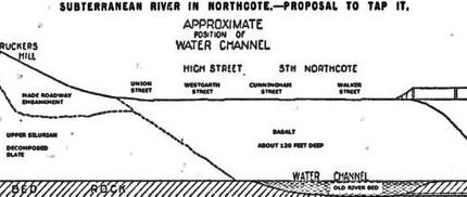
The likelihood of a mystery river was first came to light in early May, 1915 when Mr. Richard Fiddes Brown, the President of the Northcote South Ratepayers Association told a routine meeting that he had seen evidence that “a substantial subterranean water channel of incalculable value to Northcote and surrounding districts for improving the Merri Creek for swimming baths, lakes and uses too innumerable to mention” flowed underneath South Northcote.
He introduced to the meeting Mr Bartle Ryan, said to have had considerable experience throughout Australia with subterranean rivers. Ryan said that there was a strong probability that a river flowed under South Northcote between Walker and Westgarth Streets “and probably crossing to Clifton Hill”.
He continued to suggest that “countless years ago”, the river would have flowed on the surface, but when the Dividing Range became a series of active volcanoes, (as was Rucker’s Hill), the basalt lava had flowed down the original watercourse and it, with other rivers had been covered over, claiming both the Yarra and Plenty Rivers were formed in the same way when normal conditions returned.
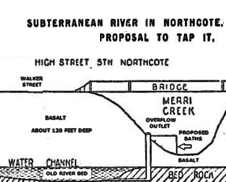
Ryan claimed he “had not the slightest doubt” that if a few bores were put down between Walker and Westgarth streets, in the Northcote Park, or at the side of the Creek opposite Ross Street, “one would not only strike the river bed, but an abundance of water”, and that a shaft driven down alongside the creek bed would give an abundant supply of underground water, probably by gravitation without need for pumping.
He added that he believed underground rivers absorbed about one-third of the total rainfall and if they could be tapped, the impact of drought periods would be drastically reduced.
Mr. Ryan then produced a report from a Mr. Reginald Murray, the former Victorian geologist and said to be a leading authority on deep river beds. Murray’s report stated that from maps of geological surveys and from his personal observations, it was evident that two deep load systems existed at the tram and railway crossings of the Merri Creek – the western one (near Merri station) corresponding to the valley of the Merri Creek and the eastern system with the ancient courses of the Yarra and Plenty Rivers.
There had been proposals put forward in previous years to dam the creek somewhere around Northcote Park to create a lake extending back under the bridge to the old Melbourne Corporation quarry site near today’s Rushall station for boating and recreation, and the Association called a conference at the All Saint’s Hall for the purpose of developing a scheme to “beautify” the Merri Creek by tapping into the underground river.
Representatives from the Pender’s Grove, West Progress, North Fitzroy, East Brunswick and Clifton Hill Progress Associations attended, and Ryan, after being voted to the chair exhibited plans from the Metropolitan Board of Works showing that underground rivers did exist. A letter was received from the Northcote branch of the Australian Native’s Association suggesting a further conference of A.N.A. branches bordering the creek be held; the request unanimously acceded to.
With the perfect clarity of hindsight, the proposal had a major flaw in that it presented few if any advantages to any other municipality other than Northcote, and then only a relatively small section of the newly-declared city.
The initial meeting was attended by A.N.A. delegates from Collingwood, Ivanhoe and Heidelberg, Coburg, Brunswick, Clifton Hill, Northcote and Preston. Ryan and Murray jointly suggested that if a weir was constructed in the neighbourhood of the Infectious Diseases Hospital, a lake could be thrown back as far as the Preston-Reservoir railway bridge over the creek south of Merri Station.
Again, this offered nothing to anyone except Northcote and perhaps a tiny section of south-eastern Brunswick, and several members asked whether the underground stream could not be tapped further upstream as a permanent supply of water in the neighbourhood of Coburg and Brunswick would be of great commercial value with land adjoining the creek extensively used for market gardens.
Ryan suggested that the mysterious underground river also probably flowed under the Merri Creek somewhere in Coburg and the water could be tapped, but it would be a much costlier exercise because of the greater depth under the surface and the likelihood of more rock being encountered when sinking the bores. The advantage in tapping the supply around Coburg was that a series of weirs could be constructed from rocks in the creek and a series of miniature lakes suitable for bathing established along the length of the creek.
The meeting passed a resolution that the secretary be instructed to call a conference of representatives from all councils and public bodies concerned with a view to approaching the Public Works Department and asking them to drill two or three test bores.
Bartle Ryan, now noted as “a mining engineer from Northcote” – directories have him at 97 Westgarth-street – in the meantime arranged a “lecture” in Brunswick on subterranean rivers and the possibility of using the water to “scour and beautify” the Merri Creek. The lecture was rescheduled so Brunswick Councillors could attend and Ryan produced a map showing of the two Northcote rivers, suggesting that by gravitation in Northcote South and a pumping station in Coburg, around a million gallons of water per day could be obtained, the depth of the river being about an average of 110 feet below the surface and the cost of boring about 12/6d per foot.
After the initial meeting of the A.N.A. delegates, the Preston branch wrote to the Shire Council suggesting it should be represented at the subsequent meeting and it was moved that the Shire President, Cr. Crispe attend, to which Crispe replied “No thanks” to laughter and it was subsequently moved no action be taken.
With somewhat more to gain, Brunswick moved to write to the Northcote Council offering to meet with them to discuss the proposal. Whether the meeting was ever held is uncertain – the two Councils were in the middle of discussions over the possible construction of a bridge over the creek at Moreland Road and the whole subterranean river scheme seems to, pun intended, gone underground.
Whether or not future generations were ever aware of the believed existence of the subterranean supply is unknown, but it seems rather strange that if it was, and with today’s advanced technology, that no attempt was made to confirm or disprove the existence of the river during the extended drought of the early part of the 21st century.
Supporting the theory of an underground system, some fifteen years before, the managers of the ham and bacon factory of Smith, Kenihan & Coy. in Bastings-street at the eastern end of Rucker’s Hill were concerned as to how they could hygienically dispose of the liquid waste from their slaughtering shed and experimented by digging a fifteen-feet deep shaft, thinking that by dropping the waste and covering it with lime may alleviate the problem.
After dumping a day’s slops down the shaft as an experiment, the parthers were astonished to find the following morning to find the liquid had disappeared.
Given it was recognised even at that time that much the land on the east, west and south of Rucker’s Hill was undermined by honey-combed porouos rock, there were immediate concerns that the offensive material may have leached into the Merri Creek, but no trace of it was ever found!
It isn’t clear how long the company continued the procedure, but it perhaps is another hint that an unknown and underground water flow may have swept the material away – but to who knows where??

